
Topic
transportation
66 record(s)
Type of resources
Available actions
Topics
INSPIRE themes
Keywords
Provided by
Years
Formats
Representation types
Update frequencies
Status
Scale
Resolution
geoDescCode
cartografia
geographicCoverage
geographicCoverageDesc
inspirecore
hvd
referenceDateRange
denominatorRange
resolutionRange
dataPolicy
openServiceType
dataType
dataFormat
-

-
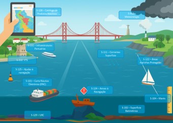
This geographic dataset (GDS) contains the coastal and local Navigational Warnings (ANAV) currently in force in S-124 format (https://registry.iho.int/productspec/list.do), in accordance with the S-100 specification (https://registry.iho.int/main.do) of the International Hydrographic Organization (https://iho.int/).. This dataset is part of the High-Value Datasets (HVD) identified in accordance with Commission Implementing Regulation (EU) 2023/138 under Directive (EU) 2019/1024 on open data and the re-use of public sector information. Citation: Instituto Hidrográfico (2026): S-124 – Navigational Warnings. https://doi.org/10.71683/a896657d-870a-4695-808f-2eec69be06d9
-
Contém os elementos das Vias de Comunicação do Tráfego Rodoviário, tais como a Rede Fundamental, Complementar, Municipal, de Utilização Limitada e Florestal do Concelho de Estarreja.
-
O conjunto de dados “Paragens da Carris Metropolitana por Freguesia” constitui uma camada temática produzida pela Transportes Metropolitanos de Lisboa (TML) no âmbito do desenvolvimento da Infraestrutura de Dados Espaciais (IDE). O objetivo deste tema é disponibilizar, para cada freguesia pertencente à Área Metropolitana de Lisboa (AML), o número total de paragens da Carris Metropolitana existentes no seu território. A informação é representada através de um único ponto por freguesia, ao qual se associa, em tabela de atributos, o número total de paragens contabilizadas para essa unidade administrativa. O dataset permite a consulta rápida, análise agregada e integração em processos de planeamento, monitorização e apoio à decisão sobre a rede de transporte público rodoviário.
-
O conjunto de dados corresponde à localização geográfica e identificação das paragens da rede da Carris Metropolitana, abrangendo os 18 municípios da Área Metropolitana de Lisboa (AML). A informação original encontra-se em formato GTFS (General Transit Feed Specification) e foi transposta para uma base de dados PostgreSQL/PostGIS no âmbito do projeto de desenvolvimento da Infraestrutura de Dados Espaciais (IDE) da Transportes Metropolitanos de Lisboa (TML). A disponibilização desta informação é da responsabilidade do Departamento de Gestão de Contratos (DgC) da TML, assegurando a sua atualização e coerência no contexto da gestão e planeamento da rede de transportes públicos rodoviários metropolitanos.
-
O presente tema reúne e caracteriza a oferta de estacionamento existente nos 18 municípios que compõem a Área Metropolitana de Lisboa (AML), constituindo uma componente essencial para a avaliação integrada das condições de acessibilidade e mobilidade urbana no contexto metropolitano. A informação foi fornecida diretamente pelos municípios da AML e posteriormente tratada, harmonizada e estruturada pela Transportes Metropolitanos de Lisboa (TML) no âmbito da elaboração do Plano Metropolitano de Mobilidade Urbana Sustentável (PMMUS). O tema apresenta-se sob formato vetorial poligonal, representando as áreas territoriais dos municípios, e inclui atributos relativos à capacidade e tipologia de estacionamento disponível A representação espacial foi elaborada através de ferramentas de análise espacial e categorização temática, aplicando-se uma rule-based expression com gradiente de cor, que permite distinguir visualmente os municípios com maior ou menor número de licenças de táxi, facilitando a interpretação dos níveis de oferta no território. A informação foi obtida a partir do portal dados.gov, tendo como entidades produtoras os municípios da AML, e posteriormente harmonizada e integrada pela Transportes Metropolitanos de Lisboa (TML) no âmbito do Plano Metropolitano de Mobilidade Urbana Sustentável (PMMUS), assegurando a uniformização estrutural e espacial dos dados. A categorização visual foi efetuada com base num gradiente de cor, representando os níveis de oferta de estacionamento — do menor ao maior número de lugares — permitindo uma leitura comparativa entre os diferentes municípios. Esta camada constitui um instrumento de análise estratégica para o planeamento da mobilidade e gestão do espaço público, permitindo identificar zonas com défice ou excesso de capacidade de estacionamento, apoiar políticas de intermodalidade e contribuir para a definição de soluções sustentáveis de estacionamento urbano e de interface com os transportes públicos.
-
A área dos portos corresponde à delimitação vetorial, com recurso a fotointerpretação, da área ocupada pela infraestrutura portuária. A vetorização teve por base os ortofotomapas produzidos pela Secretaria Regional da Ciência, Tecnologia e Equipamentos, à escala 1:5 000 para as ilhas dos grupos ocidental, central e oriental. Serviram de apoio à vetorização as delimitações das áreas dos portos incluídas no planos de ordenamento da orla costeira.
-
Contém os Eixos das Vias de Comunicação do Tráfego Rodoviário, tais como a Rede Fundamental, Complementar, Municipal, de Utilização Limitada e Florestal do Concelho de Estarreja.
-
Contém os Eixos das Vias de Comunicação do Tráfego Rodoviário, tais como a Rede Fundamental, Complementar, Municipal, de Utilização Limitada e Florestal do Concelho de Ovar.
-
Contém os elementos das Vias de Comunicação do Tráfego Rodoviário, tais como a Rede Fundamental, Complementar, Municipal, de Utilização Limitada e Florestal do Concelho de Ovar.