
denominator
0
199 record(s)
Type of resources
Available actions
Topics
INSPIRE themes
Keywords
Contact for the resource
Provided by
Years
Formats
Representation types
Update frequencies
Status
Scale
geoDescCode
cartografia
geographicCoverage
geographicCoverageDesc
inspirecore
hvd
referenceDateRange
denominatorRange
resolutionRange
dataPolicy
openServiceType
dataType
dataFormat
-
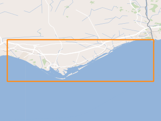
The current artificial reefs were deployed, starting with a pilot project in 1990, in order to serve as instrument for the revitalization of coastal ecosystems, planning of coastal fisheries and integrated coastal zone management. Each reef is composed by, at least, 2940 concrete modules with a weight of 3 tons and 36 large modules with more than 40 tons each. The reef complex groups 20,748 modules (with a total volume of over 100,000 m3), occupying discontinuously a total area of approximately 43.5 km2, with an area of influence greater than 67 km2.
-
Limits used for the issuance of Meteorological Forecast Reports for Maritime Navigation in the areas of sea of national responsibility (Mainland Portugal, Azores and Madeira), inserted mainly in METAREA II, according to the standards defined by the Global Maritime Distress and Safety System (GMDSS).
-
IPMA conducts regularly, since 1996, monitoring campaigns of bivalve molluscs banks that occur in the oceanic coast of the South West zone, in order to assess their condition. These campaigns allow the adjustment of the fishing effort and fishing quotas to the state of resources in order to not compromise its sustainability.This resource shows the geographic distribution of white clam biomass index (g/5 minutes per drag) recorded during the bivalve banks monitoring campaign held in June 2014.
-
Within Portugal's National Biological Sampling Project (PNAB) a set of activities are conducted in the collection, management and use of biological data, collected from the registered commercial fleet in mainland Portugal (fisheries-dependent data) and several research surveys (independent fisheries data). These activities allow the assessment of the state of fishery resources, population structure, distribution and abundance of resources, diversity and dynamics of biological communities associated with the fishery resources and biological studies (growth, reproduction).This resource shows the geographic distribution of european hake abundancy index (nr. individuals/hour) registered during the DEMERSAL2010 campaign in September 2010.
-
Areas that evidence the occurrence of submarine landslides, located between the Middle Atlantic Rift zone (Azores archipelago) and the Continental margin.
-
Delimitation of areas and identification of geological formations with potential for CO2 storage in mainland Portugal and its respective Exclusive Economic Zone (EEZ). The areas were obtained from a combination of historical data (mechanical oil exploration surveys and their geophysical logs and geophysical prospecting using the seismic reflection method), lithostratigraphic interpretation, requirements for storage in saline aquifers, as well as an update of the results of the COMET, CO2STOP and HYSTORIES projects, carried out in the framework of the CSA-GSEU project (WP3 Geoenergy, thematic subgroup CO2 and Hydrogen Storage).
-
Location of structures resulting from the submarine fluids emissions, such as: mud volcanoes (methane hydrates); Pockmaks (methane) and hydrothermal vents (fluids enriched in salts and metallic elements), located between the Mid-Atlantic Rift zone (Azores archipelago) and the continental margin.
-
Sedimentological characterization of part of the continental shelf. Folk classification (7 classes).
-

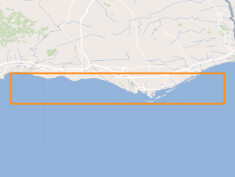
The Nazaré Artificial Reef deployed in 2010, covering an area of apr. 3 Km2 was a public project commissioned by the Nazaré Council, with the technical and scientific support of the multidisplinary research team from IPMA.
-
Earthquakes (epicenters) and areas that mark large submarine landslides of sedimentary material, which caused tsunamis whose impact was recorded on the Portuguese coast.