
geographicCoverageDesc
geographicCoverage_undefined
384 record(s)
Type of resources
Available actions
Topics
INSPIRE themes
Keywords
Contact for the resource
orgNameSNIG
Provided by
Years
Formats
Representation types
Update frequencies
Status
Service types
Scale
Resolution
geoDescCode
cartografia
geographicCoverage
geographicCoverageDesc
inspirecore
hvd
referenceDateRange
denominatorRange
resolutionRange
dataPolicy
openServiceType
dataType
dataFormat
-
-
Estabelecimentos abrangidos (DL 150/2015): Localização pontual; Estabelecimento; Nível de Perigosidade (Superior/Inferior)
-
Estabelecimentos abrangidos (DL 150/2015): Localização pontual; Estabelecimento; Nível de Perigosidade (Superior/Inferior)
-
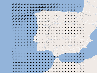
Three-hourly forecast maps of wind direction and intensity at 10 meters in the Iberian Peninsula, generated with the AROME model at 00UTC for the next 48 hours. This visualization service includes the individual layers and also a multidimensional layer that brings all of them together.
-
Visualization service (WMS) from Map of the monthly total precipitation, during the period 1971-2000, obtained by multivariate regression with altitude and distance to the coast, explanatory variables, and ordinary kriging of residues.
-
Serviço de visualização das Centrais Hídricas (grandes hídricas e mini-hídricas) de Portugal Continental, licenciados ou em fase de licenciamento pela Direção-Geral de Energia e Geologia. Este conjunto de dados integra os Conjuntos de Dados de Elevado Valor/HVD identificados de acordo com o Regulamento de Execução n.º 2023/138 da Diretiva (UE) 2019/1024, relativa aos dados abertos e à reutilização de informações do setor público.
-
Visualization service (WMS) from map of the monthly maximum air temperature, mean values of the period 1971-2000, obtained by multivariate regression with altitude and distance to the coast, explanatory variables, and ordinary kriging of residues.
-
Serviço de visualização das Captações de Água de Nascente em Portugal Continental. Este conjunto de dados integra os Conjuntos de Dados de Elevado Valor/HVD identificados de acordo com o Regulamento de Execução n.º 2023/138 da Diretiva (UE) 2019/1024, relativa aos dados abertos e à reutilização de informações do setor público.
-
Serviço de Visualização (WMS) da Planta de Condicionantes e Planta de Síntese do Plano de Ordenamento da Paisagem Protegida de Interesse Regional da Cultura da Vinha de Ilha do Pico, publicado através do Decreto Regulamentar Regional n.º 7/2014/A, de 6 de maio.
-
Delimitação e classificação das zonas litorais e estuarino-lagunares de produção de moluscos e bivalves localizadas no Continente, inclui as versões não operacionais, publicadas em Diário da República desde 2014. Para consultar mais informação sobre a situação de classificações e/ou interdições, recomenda-se a consulta do site institucional do IPMA.