
Type
map
2 record(s)
Type of resources
Available actions
INSPIRE themes
Provided by
Years
Formats
Representation types
Update frequencies
Status
Scale
geoDescCode
cartografia
geographicCoverage
geographicCoverageDesc
referenceDateRange
denominatorRange
resolutionRange
dataPolicy
openServiceType
dataType
dataFormat
-
O Programa Regional de Alterações Climáticas - Região Autónoma dos Açores (RAA), resulta da Resolução do Conselho de Governo n.º 123/2011, de 19 de outubro, que aprovou a Estratégia Regional para as Alterações Climáticas (ERAC), desenvolvida pela Comissão para as Alterações Climáticas na Região Autónoma dos Açores (ComClima), criada pela Resolução do Conselho do Governo n.º 109/2009, de 30 de junho de 2009, e tem como objetivo central criar condições operacionais para a implementação da ERAC.
-
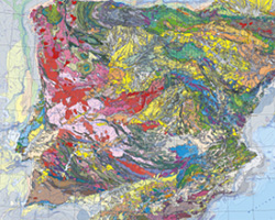
The geological map of Spain and Portugal at 1:1 000 000 scale is a renewed version of the geological map of the Iberian Peninsula and the territories of Ceuta, Melilla and the Balearic, Canaries, Azores and Madeira islands. This small-scale map is edited jointly periodically by the Geological surveys of Spain (IGME) and Portugal (LNEG). This new version includes for the first time the geological information of the Spanish and Portuguese continental shelves and also the geology of the Atlantic Portuguese islands. This map records all the new geological knowledge provided by the complete survey at 1:50 000 scale in Spain (IGME’s MAGNA Plan) and the systematic geological mapping series developed in Portugal by the LNEG. The continental portion of the map was compiled starting from original drafts at 1:400 000 scale made for every main geological unit: Iberian Variscan Massif, Pyrenees, Betics, Cantabrian and Iberian cordilleras and the Duero, Ebro and Tajo Cenozoic basins for the territory of Spain and the geological maps at 1:200 000 scale in Portugal.