
Keyword
Oceanos
205 record(s)
Type of resources
Available actions
INSPIRE themes
Provided by
Years
Formats
Representation types
Update frequencies
Status
Scale
Resolution
geoDescCode
cartografia
geographicCoverage
geographicCoverageDesc
inspirecore
hvd
referenceDateRange
denominatorRange
resolutionRange
dataPolicy
openServiceType
dataType
dataFormat
-
Ocean thermal fronts are produced daily "detected" with the SIED algorithm - Single Image Edge Detection (Cayula and Cornillon, 1992) applied of the sea surface temperature in the HYCOM model (HYbrid Coordinate Ocean Model) available at DEIMOS and provided / supplies by IH.
-
Carta obtida por georeferenciação a partir dos ortofotomas de 2007 , produzida Divisão dos Sistemas de Informação Geográfica.
-
Este conjunto de dados geográficos contém os navios naufragados (wrecks) representados na cartografia náutica. As posições geográficas dos navios naufragados podem ser representados através de pontos (point) ou áreas (área) com as diferentes categorias: navios naufragados (WRECKS), áreas de destroços (OBSTRN) e áreas restritas relativas a wrecks históricos (RESARE). Este conjunto de dados integra os Conjuntos de Dados de Elevado Valor/HVD identificados de acordo com o Regulamento de Execução n.º 2023/138 da Diretiva (UE) 2019/1024, relativa aos dados abertos e à reutilização de informações do setor público.
-

The TOPOMED-FREEZE campaign was organized as a joint campaign of the TOPOMED and FREEZE projects sponsored by the Fundação para a Ciência e a Tecnologia (FCT) (Plate reorganization in the western Mediterranean: lithospheric causes and topographic consequences, TOPOEUROPE/0001/2007; Submarine FREshwater dischargEs: characteriZation and Evaluation study on their impact on the Algarve coastal ecosystems, PTDC/MAR/102030/2008). These two projects share complementary study areas and objectives. The first concentrates on the effects of neotectonics on the evolution of landscape and environments and the second on the investigation of Submarine Fresh-Water Discharges.
-
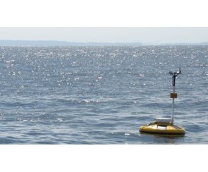
Este Conjunto de Dados Geográficos (CDG) contém a rede de boias multiparamétricas, localizadas em Portugal Continental, mantidas pelo Instituto Hidrográfico.
-
Este Conjunto de Dados Geográficos (CDG) contém a rede maregráfica internacional, a rede maregráfica nacional e a rede maregráfica nacional da Direção Geral do Território (DGT).
-

Within Portugal's National Biological Sampling Project (PNAB) a set of activities are conducted in the collection, management and use of biological data, collected from the registered commercial fleet in mainland Portugal (fisheries-dependent data) and several research surveys (independent fisheries data). These activities allow the assessment of the state of fishery resources, population structure, distribution and abundance of resources, diversity and dynamics of biological communities associated with the fishery resources and biological studies (growth, reproduction).This resource shows the geographic distribution of mediterranean horse mackerel abundancy index (nr. individuals/hour) registered during the PELAGO09 acoustic campaign in April 2009.
-
Within Portugal's National Biological Sampling Project (PNAB) a set of activities are conducted in the collection, management and use of biological data, collected from the registered commercial fleet in mainland Portugal (fisheries-dependent data) and several research surveys (independent fisheries data). These activities allow the assessment of the state of fishery resources, population structure, distribution and abundance of resources, diversity and dynamics of biological communities associated with the fishery resources and biological studies (growth, reproduction).This resource shows the geographic distribution of arrow shrimp abundancy index (nr. individuals/hour) registered during the CRUSTACEOS2014 campaign in June 2014.
-
Within Portugal's National Biological Sampling Project (PNAB) a set of activities are conducted in the collection, management and use of biological data, collected from the registered commercial fleet in mainland Portugal (fisheries-dependent data) and several research surveys (independent fisheries data). These activities allow the assessment of the state of fishery resources, population structure, distribution and abundance of resources, diversity and dynamics of biological communities associated with the fishery resources and biological studies (growth, reproduction).This resource shows the geographic distribution of deep-water rose shrimp abundancy index (nr. individuals/hour) registered during the DEMERSAL2009 campaign in September 2009.
-

Microbiological monitoring of bivalve mollusc production areas in mainland Portugal, since the year 2014, performed by quantification of Escherichia coli in meat and liquid intravalvular live bivalve, according to the sample planning. These analyzes are part of the National monitoring system of bivalve mollusc production areas and are considered in the classification of these areas and in the decision-making relative to their status. The data is collected according to the Regulation (EC) No 854/2004 of the European Parliament and of the Council of 29 April 2004 and the rules set out in Decree No. 1421/2006 of the Ministries of Economy and Innovation and Agriculture, Rural Development and Fisheries of 21 December 2006.