
Keyword
Falhas
10 record(s)
Type of resources
Available actions
INSPIRE themes
Provided by
Years
Formats
Representation types
Update frequencies
Scale
geoDescCode
cartografia
geographicCoverage
geographicCoverageDesc
inspirecore
hvd
referenceDateRange
denominatorRange
resolutionRange
dataPolicy
openServiceType
dataType
dataFormat
-
Geological Map of the Algarve Region, scale 1:100 000, produced by the Geological Survey of Portugal in 1992, as part of systematic geological surveys of the Meso-Cenozoic coast of the Algarve.
-
Carta geológica preparada por Fernando Moitinho de Almeida com base na Carta Geológica de Lisboa à escala 1:20 000 publicada em 1940 e no esquema do Complexo Basáltico de Lisboa de G. Zbyszewski publicado em 1952. Informação mais detalhada de cada uma das folhas disponível através dos seguintes endereços: Folha 1 - https://sig.lneg.pt/metadados/catalog/search/resource/details.page?uuid=94b5ccc6ac5a4677ad63927bae9d8048 Folha 2 - https://sig.lneg.pt/metadados/catalog/search/resource/details.page?uuid=e9c4b07ed3404489af8980a4de99c47f Folha 3 - https://sig.lneg.pt/metadados/catalog/search/resource/details.page?uuid=8d7c029acd7346e9bc9366d92d13f77b Folha 4 - https://sig.lneg.pt/metadados/catalog/search/resource/details.page?uuid=d9bbb46be0d14af0b8025cbec954fd5d
-
Geological Map of Portugal, at scale 1:200 000, composed of the sheets published at this scale (Sheets: 1, 2, 4, 6, 7 and 8).
-
Falhas Geológicas da Região Autónoma dos Açores. Cartografia vetorial produzida à escala 1: 25 000 no âmbito da elaboração do Plano Regional da Água (PRA) dos Açores, publicado através do Decreto Legislativo Regional n.º 19/2003/A, de 23 de Abril. Os dados geográficos do PRA foram obtidos através da recolha e processamento de um significativo conjunto de informação georeferenciada, incluindo elementos e bases cartográficas provenientes do IGeoE e do Plano Regional do Ordenamento do Território dos Açores (PROTA). Este conjunto de dados integra os Conjuntos de Dados de Elevado Valor/HVD identificados de acordo com o Regulamento de Execução n.º 2023/138 da Diretiva (UE) 2019/1024, relativa aos dados abertos e à reutilização de informações do setor público.
-
Geological Map of Portugal at scale 1:50 000, consisting of sheets published at this scale in paper and/or digital format. Includes geological maps of the Madeira and Azores Archipelagos.
-
A Carta Geológica da Área Metropolitana de Lisboa (AML), à escala 1:100 000, foi produzida pelo Instituto Geológico e Mineiro (IGM)/Instituto Nacional de Engenharia, Tecnologia e Inovação (INETI), em 2005, no âmbito do projeto de "Revisão e Atualização da Cartografia Geológica da Área Metropolitana de Lisboa".
-
The geological map of Spain and Portugal at 1:1 000 000 scale is a renewed version of the geological map of the Iberian Peninsula and the territories of Ceuta, Melilla and the Balearic, Canaries, Azores and Madeira islands. This small-scale map is edited jointly periodically by the Geological surveys of Spain (IGME) and Portugal (LNEG). This new version includes for the first time the geological information of the Spanish and Portuguese continental shelves and also the geology of the Atlantic Portuguese islands. This map records all the new geological knowledge provided by the complete survey at 1:50 000 scale in Spain (IGME’s MAGNA Plan) and the systematic geological mapping series developed in Portugal by the LNEG. The continental portion of the map was compiled starting from original drafts at 1:400 000 scale made for every main geological unit: Iberian Variscan Massif, Pyrenees, Betics, Cantabrian and Iberian cordilleras and the Duero, Ebro and Tajo Cenozoic basins for the territory of Spain and the geological maps at 1:200 000 scale in Portugal.
-
Fifth edition of the Geological Map of Portugal, scale 1:500 000 published by the Geologic Survey of Portugal in 1992.
-
Geological map data of Spain and Portugal at 1:1 000 000 scale modified according to INSPIRE data specifications for the Geology theme. Layers depicting Geologic Units are classified according to ages and lithologies from INSPIRE vocabularies.
-
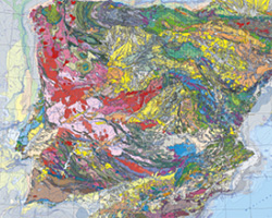
The Geological Map of Portugal at a scale of 1:1 000 000, published by LNEG in 2010, constitutes the synthesis document of the current knowledge about the geology of mainland Portugal and all insular territory: the Azores and Madeira Archipelagos. This map includes for the first time the geology of the continental shelf around mainland Portugal, drawing on over 30 years of marine geological research. The map comprises: a Geological Map of Mainland Portugal, a Geological Map of the Continental Shelf, and separate geological maps for the Azores and Madeira archipelagos (all at a scale of 1:1 000 000). Additionally, it includes a Neotectonic Scheme of Mainland Portugal with Hypsometry at a scale of 1:4 000 000, a Tectono-Stratigraphic Scheme at 1:5 000 000, and a Location Map at 1:20 000 000.