
Keyword
Limites Estabelecidos por Lei ou Convenção
33 record(s)
Type of resources
Available actions
INSPIRE themes
Provided by
Years
Formats
Representation types
Update frequencies
Status
Service types
Scale
geoDescCode
cartografia
geographicCoverage
geographicCoverageDesc
inspirecore
hvd
referenceDateRange
denominatorRange
resolutionRange
dataPolicy
openServiceType
dataType
dataFormat
-
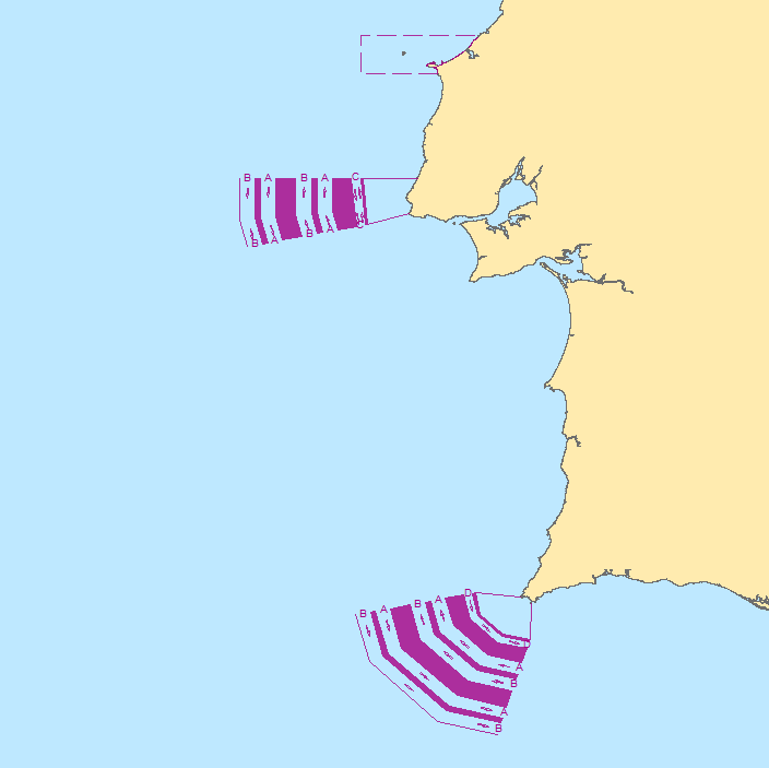
Viewing Service according to the INSPIRE profile (ISO19128-WMS 1.3.0), from the location limits used for the issuance of Meteorological Forecast Reports for Maritime Navigation in the areas of sea of national responsibility (Mainland Portugal, Azores and Madeira), inserted mainly in METAREA II, according to the standards defined by the Global Maritime Distress and Safety System (GMDSS).
-
Limits used for the issuance of Meteorological Forecast Reports for Maritime Navigation in the areas of sea of national responsibility (Mainland Portugal, Azores and Madeira), inserted mainly in METAREA II, according to the standards defined by the Global Maritime Distress and Safety System (GMDSS).
-
Web map service with the Biogenetic Reserves Network of the Council of Europe in Portugal mainland. These reserves were integrated into the National Network of Protected Areas, so this dataset at this time has only a historical character.These service relates only to biogenetic reserves that are located in marine, estuarine and coastal environments.
-

The coastline of Madeira Autonomous Region (Madeira, Porto Santo, Desertas and Selvagens), was based on Geometric Registration of Rustic Property (CGPR), with scales of 1:500 and 1:1000. It was subsequently updated based on data from Hydrographic Institute and orthophotos. The administrative divisions have CGPR bases with scales of 1:500, 1:1000, 1:2000 and 1:5000. Legal instruments were used, with the help of the Local Authorities (Municipal and Parish Councils). In this data set are present DICOFRE codes and names of their parish.
-
Web feature service with the Biogenetic Reserves Network of the Council of Europe in Portugal mainland. These reserves were integrated into the National Network of Protected Areas, so this dataset at this time has only a historical character.These service relates only to biogenetic reserves that are located in marine, estuarine and coastal environments.
-
Este tema contém os Esquemas de Separação de Tráfego (EST) para segurança da navegação ao longo da costa Portuguesa, respectivamente o EST do Cabo da Roca e o EST do Cabo de São Vicente . Inclui ar Área A Evitar (AAE) das Berlengas. Este conjunto de dados integra os Conjuntos de Dados de Elevado Valor/HVD identificados de acordo com o Regulamento de Execução n.º 2023/138 da Diretiva (UE) 2019/1024, relativa aos dados abertos e à reutilização de informações do setor público.
-
Web map service with the areas which, through scientific criteria, have been identified as important for the healthy functioning ecologically and biologically of oceans and the services that they provide.
-
Web maps service with the zonation of Berlengas biosphere reserve. This Biosphere Reserve includes the totality of the Berlengas archipelago, as well as the adjacent marine area to a maximum depth of 520m. The importance of Berlengas as an island ecosystem, the biological value of the surrounding marine area, the botanical interest, its role as a place of passage and habitat of migratory waterbirds and the presence of interesting underwater archaeological heritage give the Berlengas an obvious ecological and cultural interest. In this dataset are included 3 levels of zone protection: Core Zone; Buffer zone; Transition zone.
-
Web map service with the limits of marine and coastal biosphere reserves. The Biosphere Reserves are samples representing of marine, land or coastal ecosystems, promoting solutions to reconcile the conservation of biodiversity with its sustainable use. Internationally recognized (UNESCO Man & Biosphere Programme), designated by national governments and remaining under sovereign jurisdiction of the states where they are located. Throughout its zonation (core, buffer and transition) have to promote three functions: conservation of natural and cultural heritage, sustainable development, dissemination and knowledge. Only the core area requires legal protection and may correspond to a pre-existing protected area as a reserve or natural park. This service relates only to the marine and/or coastal biosphere reserves.