
Grelha Europeia (PTRA08/LAEA-Europe) da Região Autónoma da Madeira - Serviço de Descarregamento
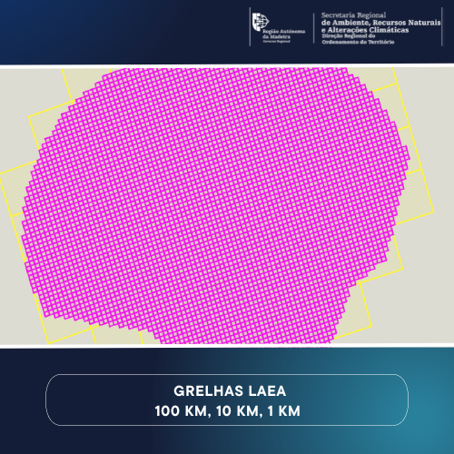
Grelha europeia (Grid_(PTRA08/LAEA-Europe) abrangindo o Arquipélago da Madeira, incluindo a Zona Económica Exclusiva (ZEE), com malhas de 1Km, 10 Km e 100 Km.
|
|
Citation proposal
. Grelha Europeia (PTRA08/LAEA-Europe) da Região Autónoma da Madeira - Serviço de Descarregamento. https://snig.dgterritorio.gov.pt/rndg/srv/api/records/a9706410-e30a-4841-8f0a-e8fa83d8285c |
INSPIRE
Identification
- File identifier
- a9706410-e30a-4841-8f0a-e8fa83d8285c XML
- Hierarchy level
- Service
Online resource
Resource identifier
Encoding
- Format
- ATOM
- Version
- Não se aplica
- Specification
Projection
Classification of data and services
Classification of data and services
- Service Type
- download
- Coupling Type
- Tight
Coupled resource
Coupled resource
Classification of data and services
- Service Type
- download
- Coupling Type
- Tight
Coupled resource
Coupled resource
Keywords
- ISO - 19119 geographic services taxonomy
-
- infoMapAccessService
- Options
-
- INSPIRECORE , Outra Cartografia
- Spatial Scope
-
- Regional
- ISO 19119 service taxonomy
-
- InfoFeatureAccessService
Other keywords
- Keywords
-
- Quadrícula geográfica , Grelha europeia , PTRA08/LAEA-Europe , Geographical grid systems , DROTe , RAM
Geographic coverage
Temporal reference
Temporal extent
Temporal extent
- Date ( Creation )
- 2019-02-22
Quality and validity
- Lineage
- Tranformação da grelha europeia ETRS89_LAEA - EPSG: 3035 (projection space: Lambert Azimuthal Equal-Area, geodetic datum: EUREF89 (ETRS89), reference ellipsoid:GRS80) em novo sistema de referência de coordenadas - EPSG: 5633 (projection space: Lambert Azimuthal Equal-Area, geodetic datum: EPSG5013:PTRA08, reference ellipsoid:GRS80).
Conformity
Conformity
Conformity
Conformity
Conformity
Conformity
Restrictions on access and use
Restrictions on access and use
Responsible organization (s)
Contact for the resource
- Organisation name
- Direção Regional do Ordenamento do Território
- drote@madeira.gov.pt
Responsible organization (s)
Contact for the resource
- Organisation name
- Direção Regional do Ordenamento do Território
- drote@madeira.gov.pt
Metadata information
Contact for the metadata
- Organisation name
- Direção Regional do Ordenamento do Território
- drote@madeira.gov.pt
- Date stamp
- 2023-06-27T16:02:25
- Metadata language
- Portuguese Portuguese
SDS
Conformance class 1: invocable
- Pass
- false
Access Point URL
Endpoint URL
Technical specification
- Date
- Explanation
- Ver a especificação citada.
Conformance class 2: interoperable
Coordinate reference system
Quality of Service
Access constraints
- Access constraints
- Other restrictions
Limitation
Use constraints
- Use constraints
- Other restrictions
Limitation
Responsible custodian
Contact for the resource
Conformance class 3: harmonized
Contains Operations
- Operation Name
- GetCapabilities
- Distributed Computing Platforms
- XML
Overviews
Provided by

Views
a9706410-e30a-4841-8f0a-e8fa83d8285c
Access to the portal
Read here the full details and access to the data.
Associated resources
Not available