
Grelha Europeia (PTRA08/LAEA-Europe) da Região Autónoma da Madeira - Serviço de Visualização
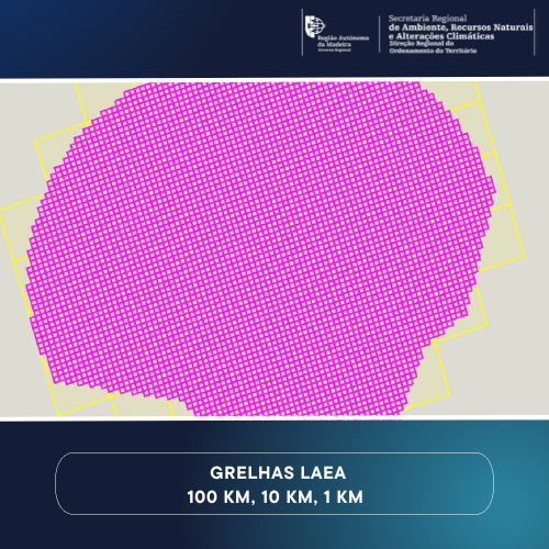
Grelha europeia (Grid_(PTRA08/LAEA-Europe) abrangindo o Arquipélago da Madeira, incluindo a Zona Económica Exclusiva (ZEE), com malhas de 1Km, 10 Km e 100 Km.
|
|
Citation proposal
. Grelha Europeia (PTRA08/LAEA-Europe) da Região Autónoma da Madeira - Serviço de Visualização. https://snig.dgterritorio.gov.pt/rndg/srv/api/records/86098a63-68f6-4b87-ba3b-5cb83cf1d9c5 |
- Identification
- Distribution
- Quality
- Spatial rep.
- Ref. system
- Content
- Portrayal
- Metadata
- Md. constraints
- Md. maintenance
- Schema info
Identification
Identification info
Service Identification (19119)
Citation
- Date ( Creation )
- 2019-02-22
- Purpose
- Criação de um serviço de visualização (WMS) da Grelha Europeia (Grid_PTRA08/LAEA-Europe) para o Arquipélago da Madeira.
Point of contact
- Maintenance and update frequency
- As needed
- ISO - 19119 geographic services taxonomy
-
- infoMapAccessService
- Options
-
- INSPIRECORE , Outra Cartografia
- Keywords
-
- Quadrícula geográfica , Grelha europeia , PTRA08/LAEA-Europe , Geographical grid systems , DROTe , RAM
- Spatial scope
-
- Regional
- ISO 19119 Service Taxonomy
-
- infoMapAccessService
- ISO 19119 service taxonomy
-
- infoMapAccessService
Legal constraints
- Access constraints
- Other restrictions
Legal constraints
- Use constraints
- Other restrictions
- Other constraints
- A reprodução e cópia para usos não comerciais é autorizada nos termos de licença Creative Commons – Atribuição (CC-BY). O uso comercial sem consentimento por escrito da DROTA é proibido. Sempre que o utilizador publique e/ou divulgue, por meio analógico ou digital, informação geográfica propriedade da Direção Regional do Ordenamento do Território, ainda que parcialmente adaptada, deverá atribuir créditos com inclusão de texto “Informação geográfica cedida pela Direção Regional do Ordenamento do Território” ou “© DROTe” ou “Fonte: DROTe”. Termos da licença Creative Commons: [https://creativecommons.org/licenses/by/3.0/ ]
- Service Type
- view
Extent
N
S
E
W
))
Geographic description
- Extent type code
- true
- Geographic identifier
- PT3
Coupled Resource
- Operation Name
- GetCapabilities
- Identifier
- 24910039-c2ff-4c02-b487-e67e99aafa39
- Coupling Type
- Tight
Contains Operations
- Operation Name
- GetCapabilities
- Distributed Computing Platforms
- XML
Distribution
Distribution
- Distribution format
-
-
WMS
(1.3.0 )
- Specification
-
WMS
(1.3.0 )
Distributor
Direção Regional do Ordenamento do Território e Ambiente
Rua Dr. Pestana Júnior, nº 6 - 3º Andar Dtº
Funchal
9064-506
Portugal
- OnLine resource
-
accessPoint
accessPoint
Quality
Data quality
Scope
- Hierarchy level
- Service
- Other
- Serviço
Conformance result
Citation
- Date ( Publication )
- 2010-11-23
- Explanation
- Ver a especificação citada.
- Pass
- true
- Statement
- Tranformação da grelha europeia ETRS89_LAEA - EPSG: 3035 (projection space: Lambert Azimuthal Equal-Area, geodetic datum: EUREF89 (ETRS89), reference ellipsoid:GRS80) em novo sistema de referência de coordenadas - EPSG: 5633 (projection space: Lambert Azimuthal Equal-Area, geodetic datum: EPSG5013:PTRA08, reference ellipsoid:GRS80).
Ref. system
- Reference system identifier
- EPSG / http://www.opengis.net/def/crs/EPSG/0/5633
Metadata
Metadata
- File identifier
- 86098a63-68f6-4b87-ba3b-5cb83cf1d9c5 XML
- Metadata language
- Portuguese Portuguese
- Character set
- UTF8
- Hierarchy level
- Service
- Hierarchy level name
- Serviço de dados geográficos
- Date stamp
- 2023-06-27T16:05:19
- Metadata standard name
- ISO 19115 Sistema de Metadados dos Açores
Point of contact
Overviews
Provided by

Views
86098a63-68f6-4b87-ba3b-5cb83cf1d9c5
Access to the portal
Read here the full details and access to the data.
Associated resources
Not available